
Case Study: YAPPENDA & Treeconomy
Unlocking Restoration Potential in Papua with High-Integrity Biomass Data
Case Study
Jun 16, 2026
Carolina Amu Trujillo
Executive Summary
Partner: YAPPENDA
Location: Cyclops Reserve and Buffer Zone, Papua, Indonesia
Methodology: Verra VM0047 V1
Technology Deployed: Treeconomy Project Site Eligibility Assessment combined with 10 m Satellite Biomass Modelling
The Mission: To blend indigenous customary stewardship with precise, high-resolution biomass metrics, establishing a technically robust foundation to protect Papua's forest frontiers.
A Foundation Rooted in Stewardship
YAPPENDA was founded with a clear, fundamental vision: to bridge the gap between Papua and the world by marrying the financial and technical resources of international markets with the profound cultural knowledge of indigenous Papuans. Operating as a nonprofit startup in Papua, the organisation works from the core principle that indigenous communities are an inseparable part of the ecosystem. For thousands of years, these communities have maintained customary systems governing forest stewardship, sacred sites, and resource use long before modern conservation frameworks existed.
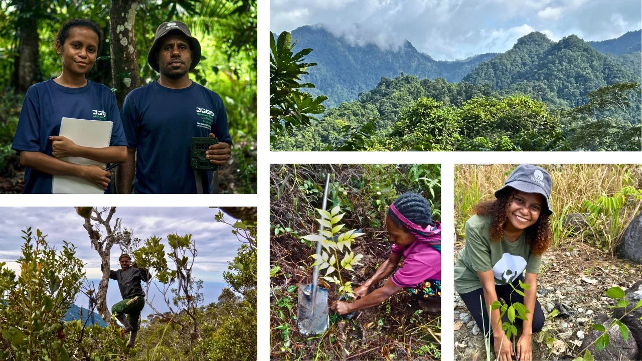
YAPPENDA Field Team: Papuan conservation practitioners conducting field monitoring and community data validation within the forest frontier.
Central to this mission is a strict philosophy on the role of technology: software and data are not meant to replace traditional custody, but to empower it. As Malcolm (Wilson) Kobak, YAPPENDA's co-founder, stated:
"We do not view technology as replacing Indigenous stewardship. Rather, technology becomes a tool that strengthens customary governance and gives communities access to evidence & finance systems that can integrate with national and international systems."
The Cyclops landscape is ecologically extraordinary and culturally alive, supporting endemic biodiversity and critical watersheds that feed Lake Sentani and Jayapura. However, Papua's intact tropical forests face accelerating outside deforestation threats from infrastructure expansion, logging, and agricultural conversion. To defend these frontiers, YAPPENDA's 2025–2030 strategic plan prioritises local resilience, youth environmental leadership, and keeping intergenerational land-use systems intact. The organisation partnered with Treeconomy to make this ancestral stewardship visible and defensible to the global market.
The Challenge: Navigating "Green Blindness" and Limited Resources
Before collaborating with Treeconomy, YAPPENDA faced a steep technical barrier: standard satellite eligibility screenings look only at low-resolution, flat land-use or land-cover maps. Because rugged, mountainous landscapes like the Cyclops range look uniformly green from a basic satellite viewpoint, standard proxy tools completely miss underlying forest degradation.
This "green blindness" systematically misclassifies degraded forest hectares as fully intact, making eligible restoration spaces entirely invisible under strict carbon standards like Verra's VM0047 methodology.
As a lean NGO operating in a poorly mapped region with limited open-source datasets, YAPPENDA lacked the internal geospatial capacity to run complex biomass analyses. Furthermore, on-the-ground field mapping in Papua is exceptionally logistically difficult and expensive due to mountainous terrain, weather limitations, and strict local regulations restricting drone usage. Relying on standard proxy data risked leaving a substantial proportion of genuinely eligible degraded hectares hidden, which would have severely undermined the project's financial scalability and long-term viability from the outset.
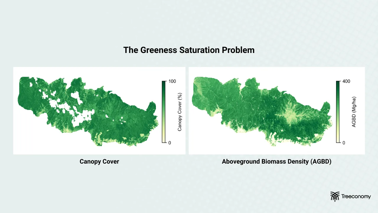
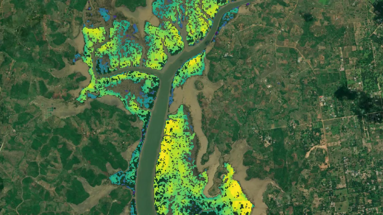
The Greenness Saturation Problem: Comparative satellite data visualisations demonstrating the 'greenness saturation problem' by contrasting flat canopy cover with granular Aboveground Biomass Density (AGBD) mapping.
The Solution: A Robust Technical Starting Point
To overcome these challenges, YAPPENDA partnered with Treeconomy to deploy a Project Site Eligibility Assessment paired with 10 m Satellite Biomass Modelling.
By assembling these high-resolution datasets during the earliest stages of development, YAPPENDA has been able to establish a transparent, technically sound starting point. Instead of relying on oversimplified land-cover classifications, the team has been able to visualise spatially explicit biomass variation across the rugged Cyclops terrain at a highly granular resolution. This pinpointed exact degraded forest hectares that traditional imagery overlooked, giving YAPPENDA the rock-solid evidence required to confidently define project boundaries under complex carbon methodologies.
As referenced in the image below, this technical shift redefines the baseline data workflow:
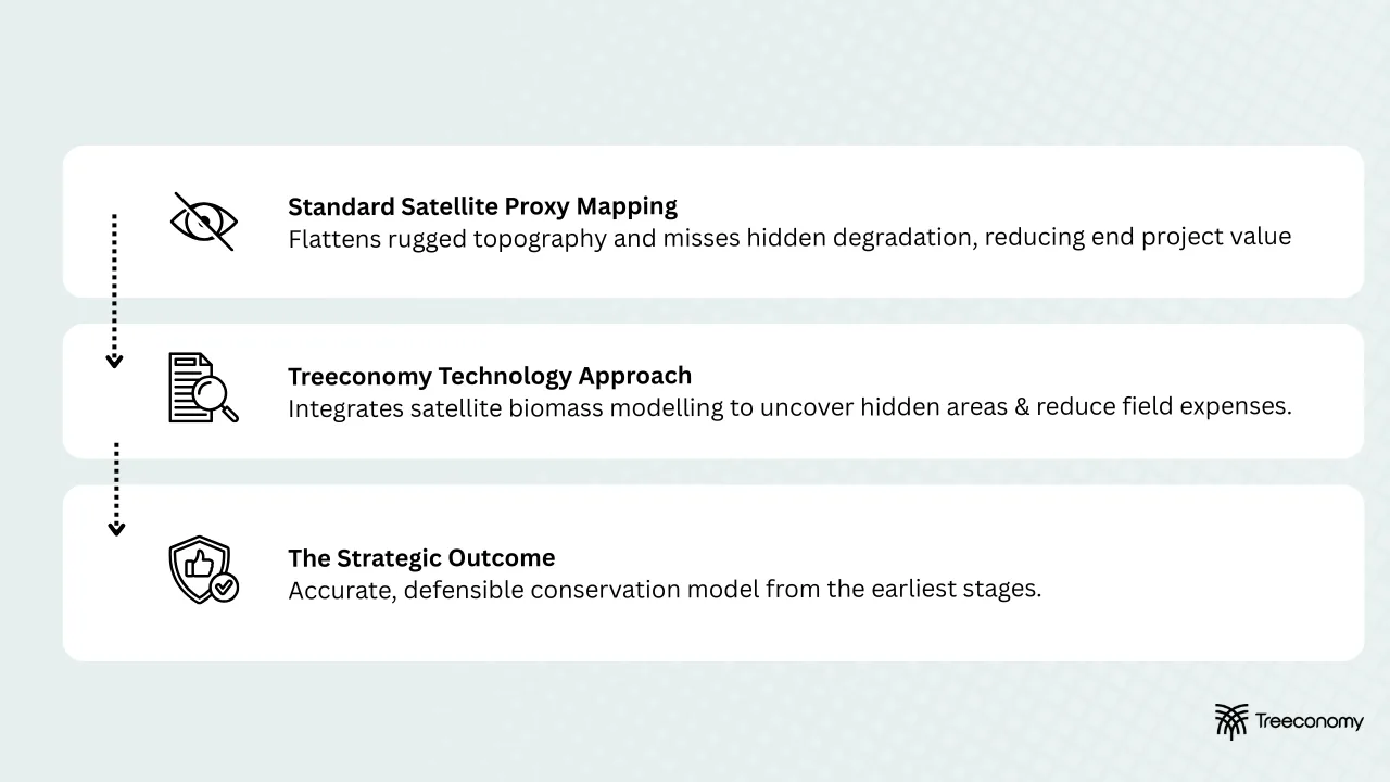
Data Workflow Diagram: Workflow diagram mapping the strategic transition from generic satellite proxy maps to Treeconomy’s integrated, high-integrity technical model.
This data strategy explicitly ensures that technology serves the people on the ground. As Malcolm noted:
"By integrating community-led ground validation with advanced biomass analytics, we have an accurate and defensible conservation model not possible through conventional datasets alone."
Treeconomy delivered this high-resolution spatial metadata via their Sherwood Platform, a web-based project visualisation and collaboration hub. Malcolm Wilson highlighted the impact on their workflow:
"Having integrated biomass modelling, spatial metadata, and project visualisation available in one platform significantly improves clarity and workflow efficiency. For a growing Indigenous-led organisation, accessible tools that reduce technical barriers while maintaining scientific integrity are extremely important."
The Impact: Alignment, Trust, and Investor Readiness
1. Operational Efficiency and Focused Resources
The combination of Treeconomy's Project Site Eligibility Assessment and 10 m Satellite Biomass Modelling has allowed YAPPENDA to maximise the efficiency of its lean resources. Having access to high-quality biomass and eligibility data early in the process has allowed the team to use their budget and manpower more effectively.
In remote landscapes characterised by mountainous terrain and limited infrastructure, broad exploratory field mapping campaigns are financially prohibitive. Rather than conducting expansive, costly, and exploratory mapping over highly challenging and restricted terrain, YAPPENDA has been able to focus and strategically target its field validation efforts, saving valuable organisational time and drastically reducing initial field-budget requirements.
2. Stakeholder Alignment and Traditional Consensus (Musyawarah)
YAPPENDA prioritises deep community consultation rooted in traditional horizontal consensus building, known locally as Musyawarah. Because Papuan traditional societies are deeply audiovisual and oral, abstract data tables or technical carbon language often create barriers to understanding.
The highly visual maps provided on Treeconomy's Sherwood platform have helped by translating technical carbon language into locally meaningful spatial context, allowing tribal leaders, communities, and local government actors to engage more fully with the project. This alignment is vital in Papua, where long-term project legitimacy depends entirely on trust, participation, and shared ownership of the process.
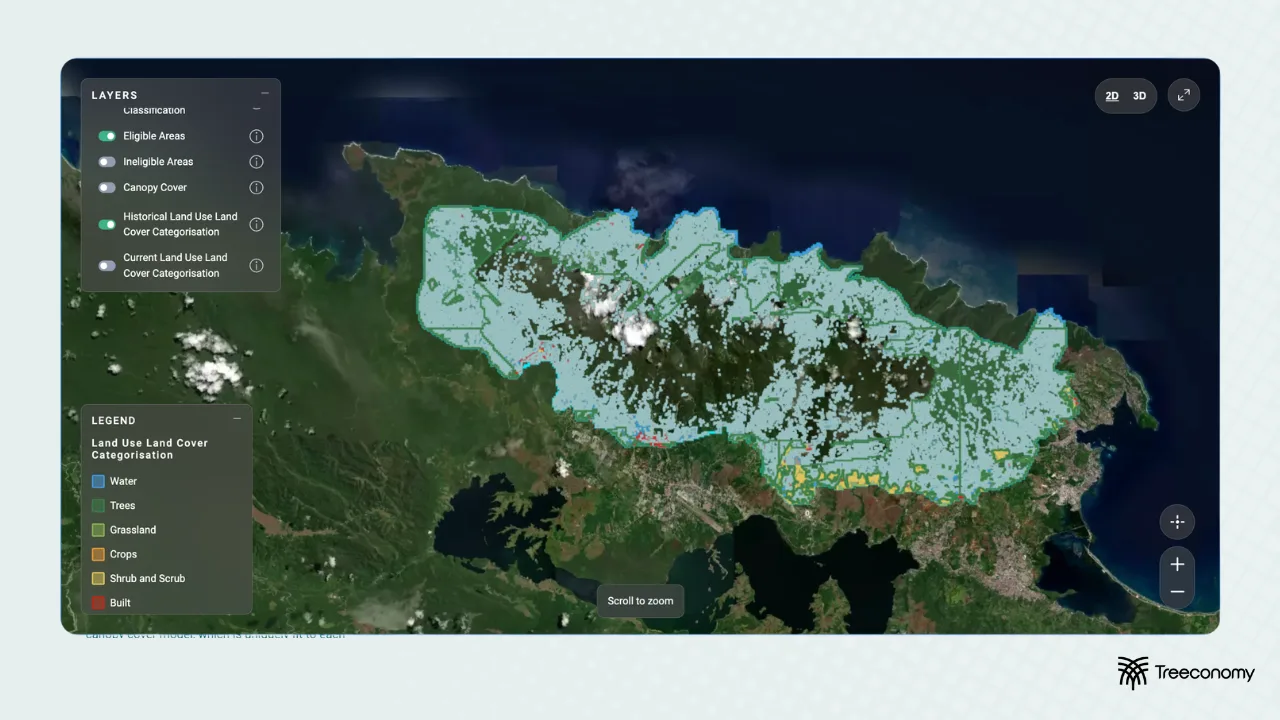
Sherwood Platform Interface: Interface view of Treeconomy's web-based Sherwood Platform, displaying high-resolution geospatial layers used to align carbon metrics with local custom land boundaries.
While the project is in its early stages and the team is still working through the provided data, the clarity enabled by these visual tools has already delivered immense value during community interactions:
"These high-resolution maps are great tools for indigenous people not familiar with maps—it's much easier to understand. "
During one of the initial community consultations, a senior community chief expressed such deep trust in the project team upon visualising their living cultural landscape that he publicly urged his community to cooperate fully, stating that he could now "die in peace" knowing the future of their ancestral lands can be secured.
3. Progressing Investment and Government Conversations
Armed with a robust, unassailable data room, YAPPENDA has been able to rapidly enter high-stakes financing discussions. Treeconomy quickly compiled vital data materials for a critical meeting with a prominent, high-profile Indonesian investor. The precision of the early biomass data allowed YAPPENDA to represent its project with absolute professionalism, successfully stimulating deep investor interest and triggering ongoing follow-up conversations for potential project replication across other parts of Indonesia.
Concurrently, this data-led credibility has strengthened YAPPENDA's ongoing conversations with local authorities. Recognising that local government agencies face infrastructure and data capacity shortages, YAPPENDA has offered to share their high-resolution data to help authorities achieve national conservation goals. This win-win approach has fostered deep trust, and the team is currently in active conversations to formalise a technical working agreement with the local conservation authority and forestry department.
Looking Ahead: A Scalable Framework
By building a transparent, scientifically rigorous foundation from day one, YAPPENDA is establishing a framework capable of withstanding the increasing global scrutiny surrounding baseline integrity in carbon markets.
While the team continues to actively pilot and work through these early development stages, the success of the Cyclops Reserve project serves as a critical first step. Looking ahead, YAPPENDA intends to leverage this exact technology stack to scale their operations into the remote Indonesian highlands—a vast region where data is historically scarce and where advanced biomass modelling will be completely invaluable for large-scale reforestation and ecosystem protection.
Ready to Build Your High-Integrity Project?
YAPPENDA's success illustrates how combining community stewardship with targeted, data-driven assessments can build the technical credibility needed to unlock finance, align stakeholders, and protect vulnerable ecosystems. If you are developing a nature-based project, Treeconomy is here to help you navigate geospatial complexities and build a fundable, high-integrity plan.
- Experience Our Biomass Engine at Zero Cost: Get a firsthand look at our data engine with no upfront commitment. Simply upload your project boundaries onto the Sherwood Platform (after creating a new account) to receive a free biomass map of your site and easily request a detailed, on-demand biomass report directly through the platform whenever you are ready.
- Learn More About Our Services: Discover how our Project Launchpad can support your project's journey with foundational options like Carbon Projections, Dynamic Performance Benchmarking, or Project Site Eligibility Assessments—all directly enhanced by our 10 m Satellite Biomass Modelling to drastically reduce data uncertainty across your site.
- Ready to Move Forward? If you are looking to de-risk your project, ensure compliance with rigorous standards like Verra VM0047, and attract high-profile investment, get in touch with our commercial team today to discuss your specific needs.