Beyond the Canopy: How We're Using Multi-Return LiDAR for a Clearer View of Carbon.
Discover how multi-return LiDAR improves carbon project accuracy, strengthens reports, and accelerates financing.
Science & Tech
Project Development
Carbon Credits
Company News
Aug 11, 2025
Jesse Smith
In the world of nature-based carbon removal, accuracy is everything. To attract investment, pass audits, and command premium prices for carbon credits, project developers need to provide transparent, defensible proof of their impact. At Treeconomy, we are constantly refining our methods with cutting-edge technology to deliver precisely that - the data-driven confidence needed to succeed.
One of our key measurement tools is LiDAR, which stands for Light Detection and Ranging. Think of it as creating a 3D scan of a forest. It’s a remote sensing technology that pulses lasers at the landscape and records how long they take to bounce back. That information is used to construct a ‘point cloud’—a series of points depicting the locations the laser reflected off the landscape, recreating its 3-D structure. For our work with forestry projects, these point clouds are invaluable, as they can reveal detailed information about the size and health of vegetated environments.
Seeing Deeper with Multi-Return LiDAR
At Treeconomy, we've long understood the importance of high quality LiDAR data. Specifically, we have found that using multi-return LiDAR provides a dramatic improvement in data quality compared to older, single-return systems.
Many basic instruments only record the first returned laser pulse from an object. In a typical single-return point cloud, this means the top canopy level will be drastically over-represented compared to components closer to the ground, such as the stem. More technical instruments, however, can “see” deeper into the vertical forest structure, particularly in the later returns. This is where the most important data for our modelling lies, making multi-return LiDAR essential for the accuracy that investors and registries demand.
From a Cloud of Points to a Forest of Insights
In practical terms, this creates a more complete picture of the vegetation structure, and thus, when we show this data to our models, it makes it that much more easier for them to output a quality result, as well as measure important variables such as Diameter at Breast Height (Dbh), stem volume, and canopy area or volume.
We can flatten this 3-D segmentation output into vectorised files that identify the location and crown shape of all trees in your project. This is the tangible data that strengthens investor reports, guides on-the-ground operational planning, and provides transparent proof of impact for audits. It gives projects an extra “wow” factor, as your stakeholders can link the maps to trees on the ground and see exactly where your project removes carbon.
Consider the progression of quality across the point cloud tiles below. In the first image, the raw input data is shown, then an image showing only higher return levels used to segment the trees, and then a final image with the complete multi-return data. In the final example we captured a lot of detail of the stem, which noticeably improves the model’s ability to distinguish one tree unit from another. The level of detail achieved was very impressive in some trial runs and we will be incorporating multi-return LiDAR in our upcoming batch of baselining projects.
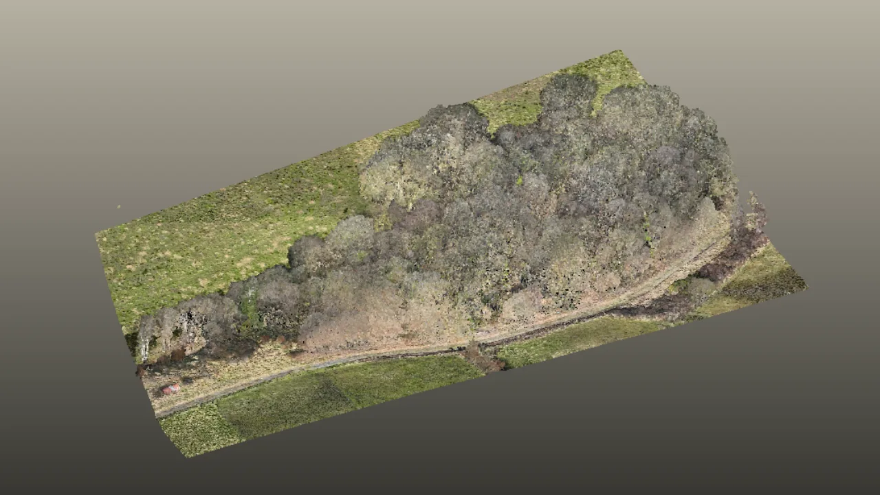
The multi-return LiDAR raw point cloud we segmented. Note that even with the RGB colouring of points, distinguishing trees is quite difficult to do by eye. It is not clear yet where most trees begin and end from visual inspection of the raw point cloud alone.
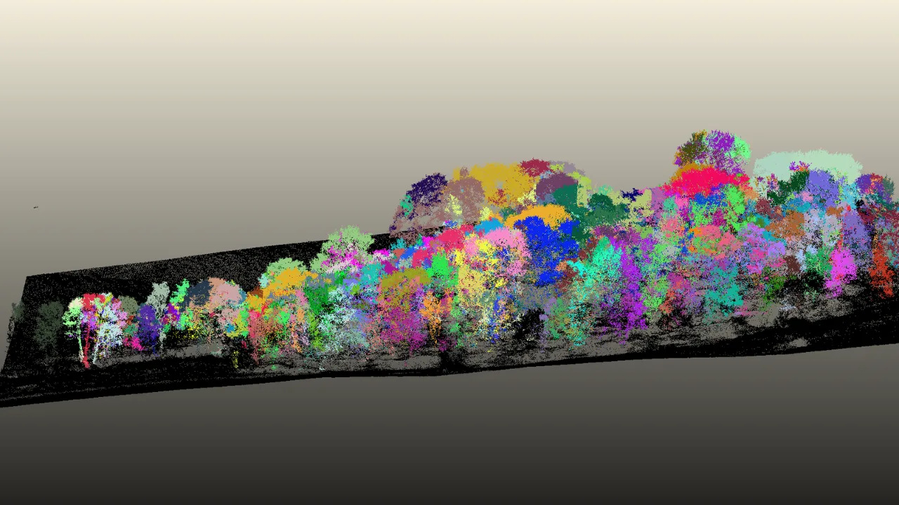
Segmentation results from only first returns. Notice that some trees can be clearly discerned, although the overall result is still messy with some crowns incorrectly being classified as multiple trees (see the highest tree to the far right of the image).
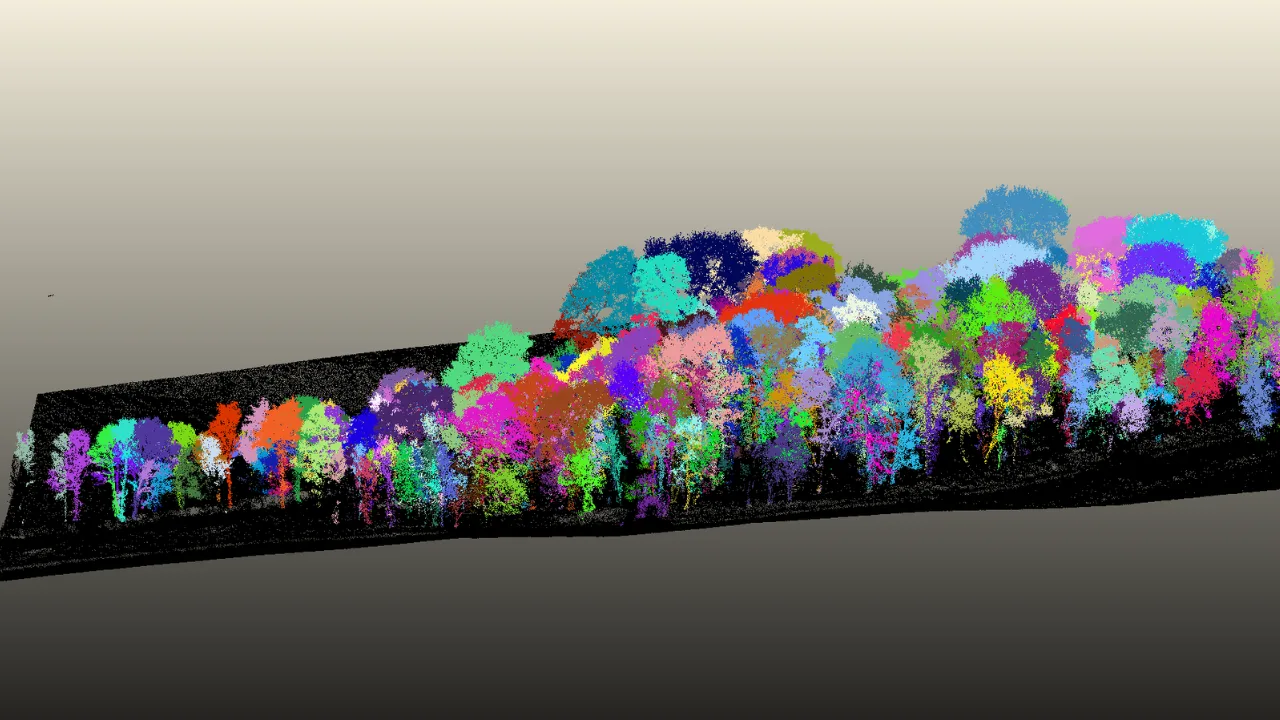
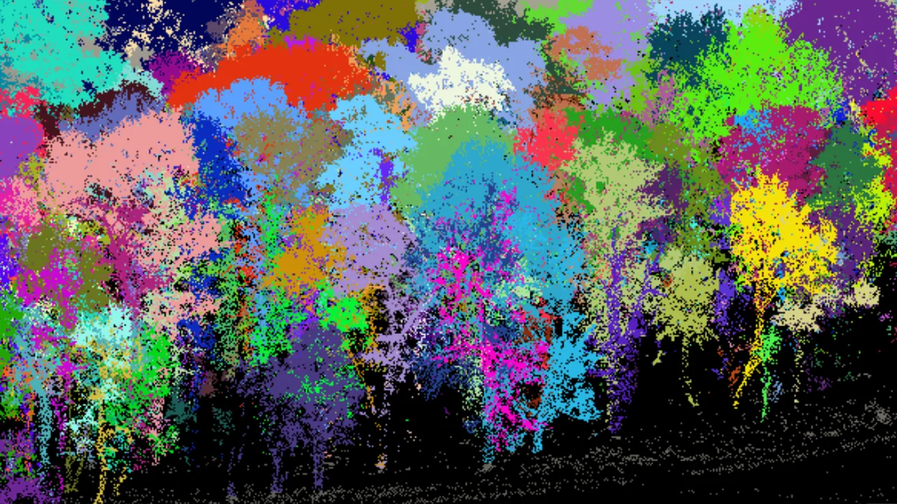
Multiple returns output (5 levels) segmentation results. Notice that it has become easier to see each tree when compared to the raw point cloud, and that the segmentations tend to be more complete and clearly distinguishable from other trees compared to the 1st returns only result. There are also more smaller trees detected that are not picked up in the prior image at all.
The End of the Tape Measure? Digitising Forest Inventories
Another exciting aspect of these tools is the ability to segment not only the tree, but components of the tree itself. We found that we could get detailed enough point clouds of stems to segment and measure stem diameter (Dbh) from the point cloud alone, an activity typically reserved for field studies using a physical tape measure.
This is a powerful capability. It dramatically reduces the time and cost of traditional forest inventories, replacing hours of fieldwork with a single surveyor using multi-return LiDAR (MRL). That benefit goes beyond simple cost savings: moving faster from data collection to analysis means you can move faster from project feasibility to financing.
In the example below, we obtained a very high quality point cloud of a complex, mature beech tree (Fagus sylvatica) scanned with terrestrial LiDAR in Wytham Woods, Oxfordshire, UK. We attempted to separate the leaves and twigs from the main stem and larger branches with an impressive level of success. While we could not completely capture some of the upper stems (see the second image), by collecting a higher density point cloud, that gap could be closed.
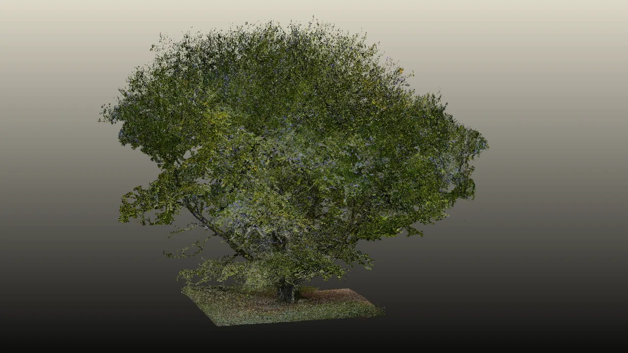
The raw beech tree point cloud, from Wytham Woods in Oxfordshire, UK.While it's hard to see through the leaves/foliage, there are multiple, large stems branching out from the trunk that would make this tree particularly challenging for most models to segment effectively.
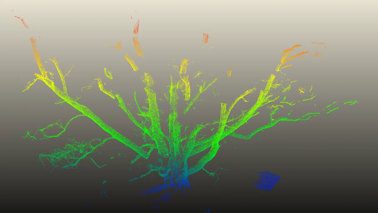
The resulting point cloud segmentation of the beech tree trunk and stems. The program has done a great job of capturing its complexity, with relatively few areas of missing data. Results can likely be improved further with a denser input point cloud.
To test the ability to measure Dbh from a tree point cloud, we obtained several segmented pine tree point clouds from southern Finland, and used a tool (shown below) that finds the points at Dbh level (1.3 m above the ground level), and calculates diameter. This is an extremely powerful capability for saving time in obtaining plot samples, wherein crews of people and hours of time can be replaced with just a single person and to collect the data instead, and process it quickly.
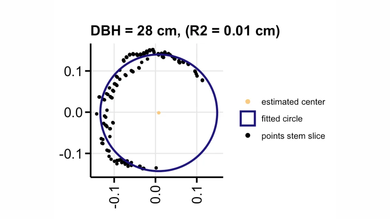
Sample output of a Dbh measurement of a pine tree (Pinus sylvestris.). This tool takes a slice of points at the 1.3 m height of the trunk and fits a circle to the 2-D slice. This allows us to obtain a realistic diameter which we can later use for models to estimate trunk volume, and eventually biomass. Note that the right side of the tree lacks points, likely due to the positioning of the TLS on the left size. Nonetheless, the diameter can still be estimated effectively.
Building Trust with Next-Generation Technology
The move from single to multi-return LiDAR is already overcoming key operational hurdles in forest monitoring. Where we were previously restricted to drone surveys during leaf-on months with single-return LIDAR, multiple return LIDAR has opened the possibility of surveys in any season. It also makes the detection of mature, dense broadleaf trees far more accurate, something that was a significant challenge in the recent past.
Our vision is to continue integrating the latest technologies into our suite of tools. By constantly pushing boundaries of what’s possible in digital measurement and reporting, we provide our customers with the high quality, accurate information needed to tell the story of their project’s impact and build the trust required to scale their work.
Ready to bring a new level of accuracy to your nature restoration project?
Whether you need a carbon baseline estimate or ongoing monitoring, our cutting-edge tools deliver the accurate, defensible data required for project validation and credit issuance. In a market where credibility is currency, this level of precision helps you build trust, command premium prices, and secure long-term offtake agreements..


